The Scientific Power of Event-Based Research After a Natural Disaster
The Center for Land Surface Hazards (CLaSH) quickly documents the geologic aftermath of natural disasters to better understand hazards, improve forecasting, and track long-lasting impacts.
Hurricanes. Wildfires. Earthquakes. These natural events can have huge impacts to communities, causing costly damage, disruptions to important infrastructure, and loss of human life. But the dangers aren’t over after the initial event ends. These events also produce big geologic changes, creating threats like landslides that cause additional damage. Worse yet, these cascading effects can continue for years after the original disaster.
Understanding how cascading hazards develop and providing the information needed to better forecast future events is a key mission of the Center for Land Surface Hazards, or CLaSH. After disaster strikes, CLaSH researchers quickly respond, coming up with a plan to measure and monitor changes to the land surface. This effort, called event-based research, is helpful for understanding how natural disasters behave and to anticipate how they might occur in the future.
Event-Based Research Is a Large, Natural Experiment
“We do event-based science in order to better understand and predict future events, which protects people and makes more resilient societies,” said Marin Clark, Professor in the Department of Earth and Environmental Science at University of Michigan and CLaSH Director. “By studying what happened in a real event, we can make measurements, and we can fine-tune our predictions for future events.”
Although natural hazard events can have big impacts, there is a limited number of extreme events every year. This relative rarity means that researchers have few opportunities to observe what happens at Earth’s surface after an event. But when they do strike, it’s all hands on deck for CLaSH teams.
These disasters are akin to running a big, natural experiment. After an event, CLaSH researchers measure what happened to the land surface and use that information to better understand what happens in the next days, weeks, or years after a natural disaster.
But when a major natural hazard strikes, time is of the essence. Details about the event are perishable, and researchers have weeks to months to document what happened in the landscape. After that, the geologic scars from the event become muted—wind and rain can blunt the edges of new features, and clean-up efforts can wipe out details on the ground. Like fading memories, evidence of natural hazards becomes less clear over time.
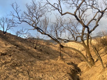
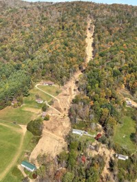
Examples of evidence from natural hazards, including a fire burn scar from the 2025 Eaton Fire in California (left) and a channelized debris flow following Hurricane Helene in 2025 (right). Event-based research captures the information from these landscape changes to better understand and forecast related hazards.
The teams balance good scientific surveys with careful coordination and respect for recovery efforts. “Our role in scientific event response is to try and learn as much as possible while not getting in the way of rescue and recovery,” said Josh West, Professor at University of Southern California, co-Director and lead of event response for CLaSH.
“Being able to collect the perishable data as soon as possible after a big event helps us to understand what happened,” he said. This information is helpful in developing and fine-tuning hazard forecasting models—an important tool used by researchers and the general public alike.
For example, after large wildfires, the U.S. Geological Survey (USGS) publishes maps that show the probabilities of debris flows occurring. “If you’re a homeowner, you can pull up those maps and look at what the debris flow probability is for your location,” explained West. Those maps are based on the scientific knowledge of the area and what happens after a disaster, but there can be large uncertainties in the maps. More observations, more data, and more insights about a disaster mean better predictions over time.
Taking a planet-sized view, hazards are a regular part of the natural rhythm of the Earth’s cycles. “With limited resources, we have to be judicious in deciding which ones we go after,” said Clark. She noted that if there is scientific promise of a particular event—say, it’s located in a unique location, in a strange climate condition, or of unusual size—gathering more scientific data might be especially appealing.
Practicality also plays a role. CLaSH is a U.S.-based group that has research observatories stretching from Alaska to Puerto Rico. The majority of their event-based research is focused in the U.S., but international work is always a possibility. “It’s obviously easier and requires less resources to do something locally, and our priority is to provide knowledge to improve the resilience of America’s communities. But hazards don’t know national borders, and if something is more far flung and looks like it’s going to be scientifically rewarding, then we will use resources for field activities internationally,” said West.
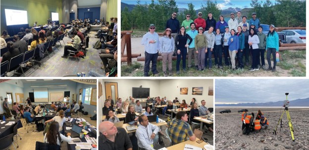
Event-based research requires coordinating between multiple groups as part of the planning process, during implementation, and even in the field — the kind of roles that CLaSH is set up to play.
Another part of that decision is coordinating with other agencies or researchers to make sure CLaSH does not duplicate efforts or get in the way of local researchers. West recalls stepping back from any investigations in Washington State when the 2025 atmospheric river storm systems caused wide-spread flooding and landsliding. West said that after talking to local university researchers and the Washington Geological Survey, CLaSH decided not to prioritize working on this event since it was already well-covered.
To decide which events to investigate, CLaSH uses a team of researchers to immediately evaluate natural disasters. “The team has setup a four-level system (Tier 0 to Tier 3) for how we respond to natural hazard events from ‘let’s talk about it briefly’ to ‘we need boots on the ground and a larger, long-term project,’” explained El Knappe, CLaSH Hazard Science Technical Lead.
Many investigatable events will warrant a Tier 1 response. “If an event occurs and it’s something we decide deserves more attention, we start by giving it virtual attention,” West explained. In a Tier 1 plan, there’s no field-based effort. Instead, researchers do a host of in-office work, including hosting coordination calls, monitoring news coverage, mapping from satellite images, and helping to collate scientific resources for other researchers and the wider community. These get summarized in a web-based Story Map, like this example following a large earthquake in the Philippines in June 2026.
In a Tier 2 or 3 response, CLaSH research teams will deploy to disaster sites to document what they see on the ground. Once on site, these teams collect perishable field data, for example by running geophysical and remote-sensing surveys on location. Tier 2 field work is more short-term survey efforts, while Tier 3 research is longer term monitoring.
Because of the investments in time, materials, and multi-year monitoring plans, Tier 3 efforts are the most rare, noted Clark.
Sharing Data is Part of the Mission
CLaSH plans on sharing all its event-based research findings publicly, said Clark. “Our vision and hope is to generate these data sets and make them available through open source repositories in as short a time period as we can,” she said.
At the moment, CLaSH researchers are collecting and processing data from several events — from the very recent, like the June 2026 Mindanao Earthquake, to tracking the long-lasting effects of the 2024 Hurricane Hilary and the 2025 LA fires. As a new research center, they are simultaneously still ironing out a plan for collecting consistent metadata and data formats. Clark said they are aiming to have their online data inventories up sometime in the fall 2026.
Until then, if a researcher is interested in using data from CLaSH event-based research, Clark suggested reaching out to the group via contact@geoclash.org.