Three case studies of cascading natural hazards: How event-based research projects develop
After a natural disaster, CLaSH researchers quickly decide if studying the event would advance scientific knowledge in hazard science– then the research begins
Natural disasters cause hundreds of billions of dollars in damages and kill tens of thousands of people each year. In these trying times when the toll from natural hazards continues to increase, there are also important scientific lessons to be learned from these events.
Researchers in the Center for Land Surface Hazards, or CLaSH, are particularly interested in capturing these scientific clues. This part of their work, called event-based research, can reveal key information about how hazards develop over time and space—and how “cascading effects” prolong the impacts of hazardous events over months to years and decades.
“We do event-based science in order to better understand and predict future events, which protects people and makes more resilient societies,” said Marin Clark, Professor in the Department of Earth and Environmental Science at University of Michigan and CLaSH Director. “By studying what happened in a real event, we can make measurements, and we can fine-tune our predictions for future events.”
A Tiered System of Research Response
When a natural hazard event hits, the CLaSH team quickly meets to discuss their potential research response. “The team has setup a four-level system (Tier 0 to Tier 3) for how we respond to natural hazard events from ‘let’s talk about it briefly’ to ‘we need boots on the ground and a larger, long-term project,’” explained El Knappe, CLaSH Hazard Science Technical Lead.
Many investigatable events will warrant a Tier 1 response. “If an event occurs and it’s something we decide deserves more attention, we start by giving it virtual attention,” CLaSH co-Director Josh West explained. In a Tier 1 plan, there’s no field-based effort. Instead, researchers do a host of in-office work, including hosting coordination calls, monitoring news coverage, mapping from satellite images and helping to collate scientific resources for other researchers and the wider community.
In a Tier 2 or 3 response, CLaSH research teams will deploy to disaster sites to document what they see on the ground. Once on site, these teams collect perishable field data, for example by running geophysical and remote-sensing surveys on location. Tier 2 field work is more short-term survey efforts, while Tier 3 research is longer term monitoring.
Because of the investments in time, materials, and multi-year monitoring plans, Tier 3 efforts are the most rare, noted Clark.
Mindanao Earthquake Triggers a Tier 1 Response
At nearly midnight on June 7, 2026, a large earthquake (magnitude 7.8) occurred south of the island of Mindanao, in the Philippines. Within the steep and tropical landscape of Mindanao, the earthquake’s shaking triggered landslides to rumble down slope, wrecking villages and sometimes burying residents. After the initial shaking, reports of damages—and the associated death toll—began to trickle in. As of June 15, the death toll was 65 people (with at least 17 of these deaths associated with landslides), with an additional 36 reported missing, and 1,400 injured.
After reviewing the conditions in Mindanao and talking to partner organizations like the US Geological Survey (USGS), CLaSH team members decided there was a potential for this to be a good case study for understanding earthquake-induced cascading hazards, noted Knappe. “From a cursory investigation of the imagery, we noticed the earthquake triggered widespread landsliding,” she said. “In the Philippines, the typhoon and rainy season is just about to begin, which in itself is a landslide trigger. Coupled with the earthquake, which destabilized the landscape, typhoons or just large precipitation events in the rainy season could produce even more landslides than usual, causing this cascade of hazards.”
Days after the Mindanao earthquake, CLaSH researchers launched a Tier 1 response effort. Their goal was to quickly document what was happening on the ground along the southern coastal area of Mindanao, where the shaking was most intense.
Knappe and Earth Sciences graduate student Anaé Lamaire collected satellite imagery taken before and after the Mindanao earthquake. They used images from Planet Imagery and Sentinel-2 which covered the southern part of Mindanao where the shaking was most severe. The team then compared the pre- and post-earthquake images to map landslides in the area.
“Modern satellites can provide really detailed imagery, allowing us to easily see changes in the landscape,” Knappe said. “Areas that would be incredibly hard to access or completely inaccessible for fieldwork are available for you. It allows you to look at the event at a much larger scale than you could if you were doing fieldwork for a similar amount of time.”
As of mid-July 2026, the team recorded nearly 6,600 new landslides in the region. The Sarangani Peninsula had the highest concentration of large landslides, even though the area was east of the highest shaking forces. From the imagery, the team also noted significant coastline changes off Sarangani Peninsula, which matched local reports.
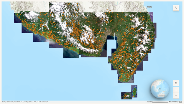
Mapped landslides from CLaSH StoryMap.
That said, Knappe noted that imagery has its limits. Satellite imagery can have gaps in coverage when clouds obscure what is happening on the ground. And while investigations from satellite images can give excellent information about what is happening at the land surface, only field investigations can reveal what happens below ground.
“Remote sensing and field work aren’t competing approaches, they’re complementary; One gives you the big picture, the other fills in the details,” Knappe said. Tier 1 investigations can also help researchers determine if on-site field work should be done at a site. “The satellite imagery might highlight regions that would benefit from more detailed observation, and the fieldwork might highlight things that aren’t visible on the satellite and change how you look at the imagery.”
The Tier 1 mapping effort on Mindanao has kickstarted discussions of collaborating with local researchers, and potentially launching a Tier 2 field campaign. Even if CLaSH decides not to add field investigations to their work, Clark mentioned continued monitoring from afar. “We want to watch the cascade through subsequent rainstorms through the rainy season and watch how that sediment moves farther downhill, how it aggregates and river channels, and how it might induce later flooding.”
West stressed that the mission of CLaSH is scientific—their goal is to better understand earthquake-induced landslides and their long-term effects—and CLaSH teams are not directly involved in operational, emergency response missions. But their event-based work can also be used by emergency managers, government organizations and agencies for disaster response.
For example, CLaSH has supplied their landslide mapping products from Mindanao to the Philippine government agencies who are coordinating responses, West noted. “There can be additional utility to the data that we’re collecting that is really intended as scientific data, especially in cases like Mindanao when some of the agencies we coordinate with like the USGS decided not to work on this event” he said.
Investigating these cascading landslide hazards in the Philippines can build general understanding about how landslides develop in mountainous areas after an earthquake, especially as a wet season starts. For example, other wet, mountainous, and seismically-active regions like the Pacific Northwest or Puerto Rico may face similar conditions during earthquake events. The CLaSH team hope that lessons learned from Mindanao will help forecast how these sequences will play out wherever they occur.
Hurricane Helene: Tier 2 Response
Hurricane Helene made landfall in Florida in September 2024 before making its way northward across the Southeastern United States. The storm caused cataclysmic damages– in North Carolina alone, Helene dropped up to 31 inches of rain.
“Helene produced catastrophic flooding that significantly exceeded the flood-of-record in almost every watershed that was affected during this event,” said Jason Dortch, research geologist at the Kentucky Geological Survey. His colleague, Ryan Thigpen (associate professor at the University of Kentucky) added that Helene also produced one of the largest landslide and debris flow outbreaks in eastern U.S. recorded history. “The debris flows in particular represented some of the largest and longest run-out systems that we have seen in this part of the southern Appalachian Blue Ridge region.”
Dortch, Thigpen and Summer Brown (senior lecturer at the University of Kentucky) headed to Appalachian communities to start documenting landslide damages. They soon found that navigating into the isolated mountain communities was an enormous challenge– roads were destroyed by roaring rivers and thundering landslides. When the roadways did escape destruction, the high winds of Helene left a tangle of trees behind. In the first few days, helicopters were the main source of transportation for many mountain communities.
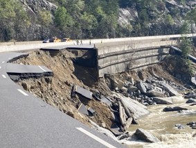
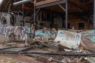
Damage along highway I-40 caused by Hurricane Helene (left; Credit: NCDOT). Asheville’s River Arts District five weeks after Hurricane Helene (right).
After the initial trip, it was clear that a Tier 2 response would be helpful. Multiple trips to North Carolina and Tennessee were planned to collect perishable data. In particular, the team wanted to collect geologic data to better understand the potential severity and frequency of extreme flood events in southern Appalachian catchments. This information would be helpful in predicting the threat of clustered landslides and debris flows in this mountainous region after extreme precipitation events.
Over 60 days, the team, led by Thigpen, collected drone and terrestrial LiDAR (a 3-D picture of the Earth’s surface with all the vegetation removed), geophysical surveys of flood deposits, and geologic samples of new and old floods. They quickly found that the Helene flooding exceeded historic floods by 50%. The discovery highlighted the need for updated maximum flood magnitudes and recurrence intervals for the region, said Dortch. The team is using the data collected on site to update the models for potential future flood conditions.
Helene initiated 2,200 landslides in the region. Thigpen noted that until Helene, “there was little work estimating the run-out distance of debris flows in the region despite their high velocities and high likelihood of intersecting with the built environment.” In light of this, the team is using their event-based data and new modeling work to understand how extreme precipitation events, on-site conditions and landslide initiation thresholds create cascading hazards. Some of this work was recently supported by a CLASH mini-grant to Sarah Johnson and Ryan Thigpen.
The data collected from Helene has been useful for other work in the region, including creating flood models for Appalachian river systems. “We are currently coordinating with multiple partners on this project, including the USGS, the North Carolina Geological Survey, and Appalachian Landslide Consultants, and we are sharing all data that we produce,” Thigpen said. He added that the team is open to sharing this data with anyone in the region and will also archive the data in CLASH databases.
LA Wildfires: Tier 3 Response
In January 2025, multiple wildfires, including the large Palisades and Eaton Fires, combined to burn more than 40,000 acres in Los Angeles and the surrounding areas. Both natural areas and urban land were burned in the fires, fueled by dry vegetation and strong winds.
The wildfires caused big changes to the vegetated slopes and the soils beneath the surface. On slopes, trees and other vegetation act like anchors and dams, holding water and sediment from tumbling downhill. Once that vegetation burns, stability is lost. “All those sediments run down slope–we call it dry ravel– and end up in the stream channels,” said Seulgi Moon, associate professor of geology at the University of California Los Angeles and associate professor at ETH Zurich. “The fire also causes the property of the geologic materials to change, creating hydrophobic – water repellent – soils.” This water repellency is often implicated in widespread flash flooding after wildfires.
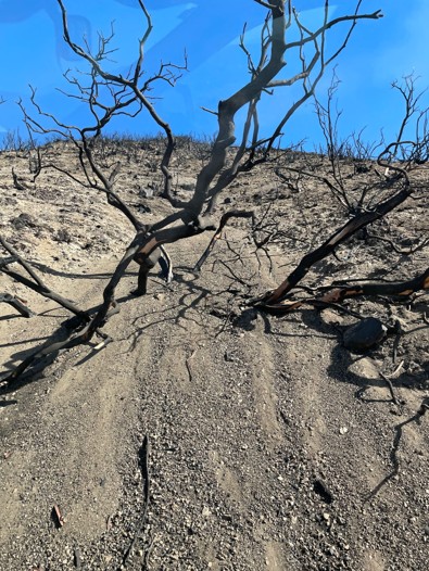
Dry ravel sediment created after the Eaton Fire in California. (Credit: USGS)
In both cases, Moon noted fire causes significant change in surface conditions, priming the channels and slopes for future mudslides, which researchers typically call debris flows. These mudslides can cause devastation to communities just recovering from wildfire, as occurred perhaps most memorably in recent history in Montecito, California, in 2018. Moon and other CLaSH researchers wanted to understand these surface changes and how they evolved over time and space– especially once rain began to fall on the burned slopes.
The team used airplane-collected LiDAR data collected over the Palisades Fire area to document the land surface both after the fire and again after the first rain storm. In the year and a half since the fires, they have collected more surveys of the area from both plane and drone flights. Moon noted that Prof. William Schopf at UCLA also granted money for the team to set up debris flow monitoring stations to track sediment and water flows with geophones and rainfall gauges.
In September 2025, CLaSH played another important role in event-based science, by gathering these researchers together for a day of discussion about their work. By coordinating efforts, these combined initiatives can better expand the observational data on post-fire landscapes and improve overall understanding of cascading hazards in wildfire regions.
Moon hopes their work can enhance future prediction efforts for debris flow hazards. “Currently, many of the warnings come from the expected rainfall, and specifically the rainfall intensity,” she said. “But with the same rainfall, depending on the surface conditions, the response can be different.” She noted that understanding the surface topography, soil, and bedrock conditions is critical for future hazard warnings. The data they collect from the LA Fires may help refine hazard maps like those the USGS publishes following wildfires across the US.
Other research projects by CLaSH team members are being coordinated with Moon’s work in response to the LA Fires. For example, Adit Ghosh, an Earth Science Ph.D. candidate at University of Southern California, is focusing on what happens to rainwater falling on burned slopes, as another piece to unraveling the puzzle of post-fire flooding and mudslides. His work is building on evidence that water repellent surfaces are only part of the story, and more is happening beneath the surface than is typically thought. He and his colleagues are trying to understand what soil structures and erosional features allow for water to penetrate through the slippery surface after fires, as well as uncovering how these features form. As in other examples of event-based science, understanding these processes requires collecting perishable data that is erased as landscapes recover.
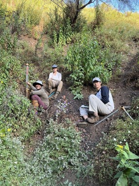
Field work conducted by graduate students in the Santa Monica Mountains following the Palisades Fire in 2025. Pictured: Adit Ghosh, Sally Keating, Yang Ma.
New CLaSH small grant awardees and researchers in the CLaSH modeling groups will be working with the data that is being collected from these events. Moon said they plan on monitoring their study sites through 2027 to document both short term and longer term changes within the wildfire sites. She said researchers from Caltech, USC, University of Connecticut, and UCLA – as well as government researchers including the USGS and California Geological Survey (CGS) – are working on projects all over the region.
Sharing Data is Part of the Mission
CLaSH plans on sharing all its event-based research findings publicly, said Clark. “Our vision and hope is to generate these data sets and make them available through open source repositories in as short a time period as we can,” she said.
At the moment, CLaSH researchers are collecting and processing data from several events — from the very recent, like the June 2026 Mindanao Earthquake, to tracking the long-lasting effects of the 2024 Hurricane Hilary and the 2025 LA fires. As a new research center, they are simultaneously still ironing out a plan for collecting consistent metadata and data formats. Clark said they are aiming to have their online data inventories up sometime in the fall 2026.
Until then, if a researcher is interested in using data from CLaSH event-based research, Clark suggested reaching out to the group via contact@geoclash.org.